Bidston Hill Underground Tunnels Click Me Bidston Hill Air Raid Tunnels Click Me Bidston Hill, 1932 Click Me Bidston Hill - Now and Then Click Me
Originally Posted by www.wirral.gov.uk
Bidston Hill
Rising to 231 feet Bidston Hill is one of the highest points on the Wirral. Its 100 acres of heathland and woodland contain mysterious rock carvings and historic buildings, as well as being a haven for wildlife amidst the urban sprawl.
The stone tablet on the Windmill describes how the local authority acquired the land for public use from Lord Vyner around the turn of the century. Evidence of earlier activities however are much less obvious.
Probably the oldest feature on the Hill is a four and a half foot long carving of a 'Sun Goddess', carved into the flat rock north-east of the Observatory - it is supposed to face the direction of the rising sun on midsummer's day and was thought to have been carved by the Norse-Irish around 1000 A.D. Another ancient carving of a horse can be found on the bare rock north of the Observatory, just before the path turns down to Bidston Village. Other, more recent rock carvings can be seen on the vertical rock face just south of the Observatory. In 1407 part of the Hill was enclosed by a wall known as Penny-a-day Dyke to create a deer park for private deer hunting. The remains can be seen along the edge of the wood (Park Wood) just below the ridge from the Mill to the Observatory.
The 'Cock-Pit' is another strange feature on the Hill to be found at the very northern end near to Bidston Hall. Consisting of a narrow circular trench, approximately 10 inches deep and 20 feet in diameter cut into the bare sandstone surrounded by tall gorse bushes. Thought to be the site where cock-fighting took place, it could also be the remains of a small gorse mill where gorse was crushed for animal feed. An old, disused mill would have been an ideal location for this illegal sport.
From 1763 a Signal Station was located on the Hill eventually consisting of over 100 flagpoles sited all along the ridge of the Hill. Mostly used to send messages to the merchants of Liverpool of incoming ships, some were also used to warn of enemy warships and ships in distress. The most visible hole that remains is approximately 30 yds north of the Windmill. In 1771 the first lighthouse was built. An octagonal building, it formed part of the chain of semaphore signals along the N. Wales coast. A message could be sent from Holyhead to Liverpool in 8 minutes!
The present lighthouse was built in 1873 (adjacent to the Observatory) and last used in 1913. Although miles from the sea, its height enabled it to be seen in conjunction with the Leasowe lighthouse. Together they enabled the ships to avoid the sandbanks in the channel. 'Wreckers' from the Wallasey area used to operate by lighting beacons to confuse the ships' captains into hitting a sandbank. Once wrecked the cargo would be collected from the shore, while the seamen were left to drown.
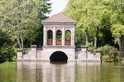
In 1866 Bidston Observatory was built, faced with sandstone excavated from the site. The equatorial telescope in the west dome was used for the observation of comets while the transit telescope in the east dome was used to determine the time from the sun, moon and stars. At exactly 1.00 p.m. each day the 'One-0'clock Gun' on Birkenhead Dock would be fired by a series of switches from the Observatory. The gun and telescopes were given to Liverpool Museum in 1962. The Hill can be reached by bus or train (Bidston railway Station is approximately half a mile away). Alternatively a car park is situated off Boundary Road near to Tam O'Shanter Urban Farm where toilets, information and refreshments can be found, 9:30 am - 4:30 pm each day.
I am fascinated by bidston hill and every time i go up there i find somthing of intrest.here are some of the things we found ths morning.Any ideas as too what any of them are welcome.
There are several of these along the park wood ridge from the mill to the observatory and beyond, the last one we could find was next to the horse north of the observatory
So different to all the other names gouged out of the sand stone and looks much older ??
It all makes perfect sense expressed in dollars and cents ,pound shillings and pence
didnt you get one from the bottom of the hill Mark?
Autowirral.co.uk - The Northwest's Biggest forum of Motoring Enthusiasts. Cruisewirral.com - The Northwest's Biggest forum of Modified Car Enthusiasts.
looking at tthem carvings, i think 1 is ancient noughts and crosses, 2 could be ancient golf and the third coud be the winner of both events?? you never know. seriously tho when i left there had just been a massive fire so i guess all sorts became exposed
All hail the posting King and thou Wiki Wirral Bumper sticker will be displayed with pride
There used to be another road up the hill starting just on the left as you look at the old picture .This is no longer there but the remains are clearly visible on the south side of the observatory
It all makes perfect sense expressed in dollars and cents ,pound shillings and pence
From 1763 a Signal Station was located on the Hill eventually consisting of over 100 flagpoles sited all along the ridge of the Hill. Mostly used to send messages to the merchants of Liverpool of incoming ships, some were also used to warn of enemy warships and ships in distress. The most visible hole that remains is approximately 30 yds north of the Windmill. In 1771 the first lighthouse was built. An octagonal building, it formed part of the chain of semaphore signals along the N. Wales coast. A message could be sent from Holyhead to Liverpool in 8 minutes!
Yep a lot of the names carved into the rock are the names of the famous "cock fighters" that spent there time on the hill. One in particular is notorious and is called "evil", the name is stil there if you look around closley.
The carving of the sun godess is believe dto date back to phoenician travellers far longer ago that 1000 years, it is estimated that it may have been 2000 years ago. The phoenicians were a sea fearing race and had similar burial practises to early christian hence the arms extended outwards.
The Cat carving is from the Phoenicians The Sun Godess is Norse
/ Dr Frick Slaps himself
More you say ?
.. Ray Bellisima is the name given to the River Mersey by the Phoenicians. It is named after the Phoenician Cat God. The female marking on Bidston hill faces the river Mersey and looks to have a cats head. Coincidence ???
thats a dead good find ..... loads of houses are starting to colapse now due to tunnels like this, as houses have been built on top of them when they werent mapped .. so no one new they exsisted ... they are since then slowly finding out where all these tunnels are as houses are starting to fall through.
ambition is a poor excuse for not having enough sense to be lazy
The so-called Sun Goddess is very unlikely to be Norse, as there is no cosmological side to Norse mythology, with their deities entirely taking on human form. They simply did not worship cosmologically.
There is almost certainly no Phonician link to this area, and most of these 'theories' are based upon odd Victorian and later historians, trying to find links from Ancient Briton to much grander predecessors than our hut dwelling ones!
It's impossible to date these carvings, as there has been nothing similar found, and as such are as likely to be early modern graffiti as they are ancient.
Also, there is no evidence that anyone called the Mersey BELLISAMA. I'm assuming someone has mixed up Ptolemy's writings on ancient Britain, where he mentions a river goddess called Belisama.
Sorry to burst a few bubbles, I more than anyone would like this to be true! Although as a post-script, any solar worship that occured in Britain would most likely be druidic, or earlier. It's just unlikely, that's all!
Just to add one more thing however: my main reason for dismissing Phoenicians is that the Mersey did not exist as a river in the time of Ptolomy, rather is was a series of pools, which only interlinked in flooding and high tides (hence Tranmere Pool, Wallasey Pool etc).
However, the Phoenicians were sun worshippers, and the idea of a female giving birth to a sun fits in nicely with both this and egyptian mythology. The Phoenicians probably traded tin in Britain, but perhaps were trading salt this far north? I thought I was a bit too negative in that last post, so thought I'd redeem myself!
sorry, this thing is annoying me now, hence the posts!! It could also be a possible early Christian symbol, arms outstretched and a sun are all known Christian symbols, although there are arguements that this is merely an evolution from Isis worship.
The so-called Sun Goddess is very unlikely to be Norse, as there is no cosmological side to Norse mythology, with their deities entirely taking on human form. They simply did not worship cosmologically.
There is almost certainly no Phonician link to this area, and most of these 'theories' are based upon odd Victorian and later historians, trying to find links from Ancient Briton to much grander predecessors than our hut dwelling ones!
It's impossible to date these carvings, as there has been nothing similar found, and as such are as likely to be early modern graffiti as they are ancient.
Also, there is no evidence that anyone called the Mersey BELLISAMA. I'm assuming someone has mixed up Ptolemy's writings on ancient Britain, where he mentions a river goddess called Belisama.
Sorry to burst a few bubbles, I more than anyone would like this to be true! Although as a post-script, any solar worship that occured in Britain would most likely be druidic, or earlier. It's just unlikely, that's all!
Im not convinced, Mark Olly who established and runs the archaeological unit CWP Archaeology (Celtic Warrington Project) whose aim is to document all prehistoric and Dark Age remains in the Merseyside & Cheshire is just one of many credible Archaeologists who have suggested this theory.. below is an extract from his website:
"The one of interest to us is that of a goddess with the moon at her feet and the face of a cat. She is known as the 'Moon Goddess' and may be related to the Egyptian lion-headed sun goddess 'Tefnut' of Heliopolis who represented the moisture in the air, clouds, mist, dew, rain and later possibly the rivers of Britain (and nowadays, probably the weather in Manchester !). She was the partner of 'Shu', God of the air, son of 'Atum' (or the great creator sun God 'Ra'), personification of the "Breath of Life" who held up the sky goddess 'Nut' from the earth god 'Geb'. In form this would make 'Tefnut' a perfect female equivalent or partner to the male Creator-God of the early Christians and Celts.
The moon symbol is undoubtably a later Celtic addition, possibly added to indicate that this version of the middle eastern goddess 'Tefnut' is associated with the river 'Belisama' (Mersey) who's original Egyptian/Phoenician name was 'Rhebelisama', goddess of moon and heaven. While there is nothing to say a river can not be represented by both the sun and moon, this might explain why cats and cat goddesses of the moon are associated with the distinctly 'solar boat' shaped river Mersey. The Egyptians and Phoenicians also tied their major solar and lunar dieties to rivers such as the famous Ra and the River Nile association. While they are renowned for trading tin from Cornwall, a Phoenician ship has been found as far north as Scotland raising the possibility that the Phoenicians first gave the name 'Rhebelisama' to the Mersey as long ago as 650 BC, well before the Romans used the name".
I've actually written a recent paper on the carvings at Bidston Hill, I don't mind sending it over if you'd like to read it.
Mark Olly is not someone I would regard as being reliable, albeit his intentions are good. He is more of a re-enactment historian, and so much of what he writes/produces on TV is not founded in archaeological or historical fact. I seem to recall him linking Birkenhead Priory to templar activity, based upon a few old tombstones (and not long after the Da Vinci code brought Templars to the forefront of people's minds!).
There is a massive amount of evidence we can point at to dismiss the carving as most likely being post-mediaeval graffitti - too much for me to type up in my lunch break!
The Belisama link is a case of pure speculation. If you look at the Ptolomy maps, the river concerned is more likely to be the Ribble than anything else. The 'solar boat' shaped Mersey was a series of pools during this time, and would certainly not resemble any shape that it does now. This argument was dismissed some time ago, I can send you a link to a Journal discussing it if you wish.
Thinking on, I've also read somewhere on this site about someone interested in rows of stones in Bidston. I've not seen them to be honest, but I have access to maps of the entire area of Bidston dating to 1665 if anyone thinks they may be of use.
Not sure if this works....but here's a scan I'm working with at the moment of Bidston Village in 1665, they formed part of a survey by a chap called Thomas Taylor who surveyed the Manor of Bidston after the Civil War. The reason for this lay in the fact that the Earl of Derby was a condemned Royalist (had his head chopped off!) and his lands were confiscated by Cromwell's new parliament. The survey was to provide some valuations of the land.
This scan only shows the main village centre, as that's what I've been working on mostly. However, I do have maps from era for all sorts of places, mostly in North Wirral.
That`s superb mate.Still legible in any case.If you have probs with posting maps,such as too big to post in 1 go then Mark can help you out.I sent him a map in 6-8 sections and he managed to stitch it together and post it as 1.
As long as no one is planning any metal detecting or digging, I'm happy to assist anyone in any archaeological/historical research in Wirral if they are interested. I'll make an effort to scan some of these older maps when I have time, and will PM them to anyone who's interested.

![[Linked Image]](https://www.wikiwirral.co.uk/forums/ubbthreads.php/ubb/showimage/id/1947/type/m/1923.jpg)

![[Linked Image]](https://www.images.wikiwirral.co.uk/forum/5274.jpg)
![[Linked Image]](https://www.images.wikiwirral.co.uk/forum/5275.jpg)
![[Linked Image]](https://www.images.wikiwirral.co.uk/forum/5213.jpg)
![[Linked Image]](https://www.images.wikiwirral.co.uk/forum/5277.jpg)
![[Linked Image]](https://www.wikiwirral.co.uk/forums/ubbthreads.php/ubb/showimage/id/3699/type/m/Bidston%20Hill,%201932.jpg)

![[Linked Image]](https://www.images.wikiwirral.co.uk/forum/5218.jpg)
![[Linked Image]](https://www.images.wikiwirral.co.uk/forum/5217.jpg)
![[Linked Image]](https://www.images.wikiwirral.co.uk/forum/5215.jpg)
![[Linked Image]](https://www.images.wikiwirral.co.uk/forum/5216.jpg)
![[Linked Image]](https://www.images.wikiwirral.co.uk/forum/5214.jpg)
![[Linked Image]](https://www.images.wikiwirral.co.uk/forum/5271.jpg)
![[Linked Image]](https://www.images.wikiwirral.co.uk/forum/5273.jpg)
![[Linked Image]](https://www.images.wikiwirral.co.uk/forum/5272.jpg)
![[Linked Image]](https://www.images.wikiwirral.co.uk/forum/5219.jpg)
![[Linked Image]](https://www.images.wikiwirral.co.uk/forum/5278.jpg)
![[Linked Image]](https://www.images.wikiwirral.co.uk/forum/5165.jpg)


![[Linked Image]](http://www.signaturebar.com/uploads/images/2037.jpg)


![[Linked Image]](http://img268.imageshack.us/img268/9940/334766523006ccdm3.jpg) Please do not adjust your mind, there is a slight problem with reality
Please do not adjust your mind, there is a slight problem with reality