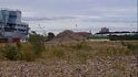
I went for a walk yesterday and noticed theses strange structures on the Wirral Way between Lees Lane and Station Road, Neston. There is about 10 of them with manholes on them, and a huge concrete pipe connecting them all together. My friend said they might have been water stops, but why are there so many in just half a mile? I suspected sewage pipes, again, why so many access points? Can anyone shed any light on these?
The guidelines for foul water drains are that no part of the drain should be more than 22.5m from an inspection point, so normally that means a maximum of 45m apart.
There's a real danger that the left will drag Britain back to the 1970s, with secure well-paid jobs, ample housing, properly-funded NHS and social care, free tuition, student grants, final salary pensions, affordable rail fares and fabulous films and music. David Osland 2025
We don't do charity in Germany, we pay taxes. Charity is a failure of governments' responsibilities - Henning Wehn
So it is a sewage pipeline installed after the train tracks were lifted? I suspected sewage pipes but the butresses had me doubting it because they look so old.