dd. I think the photo (Is this on the Wirral ?) is indeed on the Wirral. On the skyline about 3/4's across to the right, is what looks like the Flaybrick Water Tower. Immediately left of it is the adjacent pumping station chimney - long demolished.
Where the photo was taken from is another matter !
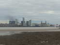
DD - Your photo was published in 2003 in "A Wirral Album" compiled by the Heswall Society. The title of the photo is "Wallasey. Tidal Mill site." and it was taken by E. Mitford Abraham circa 1900. The modern text which accompanies the photo is sceptical of there having been a tidal mill on the site. The author of the text probably did not know that Burdett had shown and named the mills on his 1777 map. As to the location and orientation of the camera when the photo was taken, I offer the following suggestion (image below). If correct, it would show (L-R in the original photo) - Mosshouse, St James church, the reservoir water tower on Boundary Road and Flaybrick cemetery chapel, also a lot of railway activity. N.B this is a suggestion, not a statement of fact.
It's not my place to say, it's been delayed because of more things coming up. Finds are coming up there from neolithic to post-med, so there's a lot to get through.
I had a mysterious PM from someone on here called TETE4 saying they had found some of the stones. I asked for more details and they never replied.
I told a few people about the stones in work and set them looking into stuff - a genealogist, a geographer and someone who's mum lives local. The latter reckons she may have seen a sandstone 'post' in the fields.
One day I'm going to venture down there.
I don't think this has anything to do with the tidal mills - too far away from Wallasey Pool. These stones are right by Bidston Village.
And another thing - I've realised that the 3 rows all run north to south.
I must admit, I've come back to this as I'm not sure on my first interpretation and the stones intrigue me. They cross over a field boundary which suggests a pre-enclosure date (mid 19th Century) but seem to respect Fender Lane which suggests the lane was there first. They don't appear on the Tithe Maps, but they didn't always display features such as stones anyway. However, you usually find that prehistoric stones of this type lead to field names called "Stone Field" "Stoney Croft" etc, whereas this field is called Rushy Meadow which suggests wetland (hence my first initial tidal mill idea). I have a copy of every single OS Map for this area since the First Edition, and they only appear in 1875 and 1912. Gone after this.
I've emailed it to my friend who is a lecturer in Prehisory anyway, just to see if there are any comparisons. They are slightly off the N-S axis, but do in fact run perfectly with the line of the field they sit in which suggests something farm related perhaps.
A mystery! I've had a quick walk around but not saw much, think I'll take the dog down later in the week with a camera and have a nose.
Your mention of the stones brought back a memory from when we used to play on Comptons field. I think it was near one of the Pill Boxes there were some huge dressed stones half buried (flat) in the ground. They were big enough to climb on and use when we would have a picnic. From memory I would say they were at least 8ft. long and about 3ft wide.
In all honesty, I'd very much doubt these were Neolithic. If they were, they'd be the biggest Neolithic monument in Europe and a local antiquarian would have easily noted these by the end of the 19th Century. The only similar prehistoric monuments are perhaps causeways, but these are a central path closed in by two rows of stones, not three. I suspect the answer lies in the landscape around the field, which needs to be explored thoroughly. Remember that this area was likely to be marshy too.
I've showed this map to a few colleagues (including a stone specialist and a prehistorian) and they are both stumped. I'd suggest they are a post-medieval feature, but this doesn't lessen the mystery surrounding them! I'd love to get to the bottom of it.
In all honesty, I'd very much doubt these were Neolithic. If they were, they'd be the biggest Neolithic monument in Europe and a local antiquarian would have easily noted these by the end of the 19th Century.
I'd have thought someone like W.F.Irvine would have mentioned them long ago.